Seven Scenic Stops Above Playas del Coco
Discover a challenging mountain hike right from Villa Buena Onda, with panoramic views of Playas del Coco, the Pacific Ocean, and Guanacaste.
1. Hike Overview
- Starting point: Villa Buena Onda front doors.
- Destination: Lookout Mountain Main Summit, with an optional Bonus Summit.
- Distance: Approximately 2 miles uphill and 2 miles downhill.
- Total distance: Approximately 4 miles round trip.
- Time required: Allow up to 2 hours.
- Difficulty: Strenuous, with very steep inclines.
- Fitness level: Intermediate to advanced.
- Terrain: Mountain roads, steep climbs, winding curves, and grassy lookout areas.
- Highlights: Panoramic views of Playas del Coco, the Pacific Ocean, and the Guanacaste coastline.
- Seven designated landmarks: Three Base Camps, Dead Man’s Curve, Final Ascent, Main Summit, and Bonus Summit.
2. Getting to the Mountain from Villa Buena Onda
- Start at Villa Buena Onda’s front doors.
- Walk down the driveway.
- Turn hard right at the bottom of the driveway.
- Continue along the straight road until it ends at Maxi Palí Road.
- Turn left onto Maxi Palí Road.
- Continue approximately ¼ mile.
- Dolphin School will be on your right.
- Turn left at Dolphin School, crossing the small bridge.
- Stay on the left-side road and begin climbing the mountain.
- Follow the road as it bends right and passes directly in front of The Lookout Restaurant.
- At the far end of the restaurant, make a hard left.
- Continue climbing behind the restaurant toward the remaining scenic stops.
3. The Seven Scenic Stops
Stop 1 — Base Camp 1: The Lookout Restaurant
- First major landmark.
- Views overlooking Playas del Coco.
- Good location for a short rest.
- Continue uphill after making the left turn at the far end of the restaurant.
Stop 2 — Base Camp 2: First Grassy Lookout
- First grassy scenic resting area.
- Platform closed to vehicular traffic.
- Open views of the surrounding landscape.
- Good opportunity for pictures.
- Hydrate before continuing uphill.
Stop 3 — Base Camp 3: Second Grassy Lookout
- Another scenic resting point.
- Platform closed to vehicular traffic.
- Higher elevation and expansive views.
- Last designated Base Camp.
- Prepare for the steeper upper mountain sections.
Stop 4 — Dead Man’s Curve
- A memorable, winding section of the mountain road.
- Steep terrain and a sharp curve.
- (No actual deaths recorded.)
Stop 5 — Final Ascent
- One of the steepest sections of the hike.
- A strenuous final climb toward the summit.
- Pace yourself and take breaks as needed.
- The Main Summit is getting close.
Stop 6 — Main Summit
- The primary destination of the hike.
- Large, open grassy platform.
- Spectacular panoramic views.
- Ideal place for photos, water, and a well-earned rest.
- The recommended turnaround point for most hikers.
Stop 7 — Bonus Summit
- Optional final climb beyond the Main Summit.
- Approximately 12 meters higher.
- Identifiable by a cement wall.
- An additional challenge for adventurous hikers.
- Return along the same route toward Villa Buena Onda.
4. Hiking Recommendations
- Bring plenty of drinking water. Hydration is especially important in Costa Rica’s tropical climate.
- Bring walking sticks for balance and stability.
- Wear comfortable hiking shoes with good traction.
- Start early in the morning to avoid the strongest heat.
- Use sunscreen and consider a hat.
- Take breaks at the three Base Camps.
- Be particularly careful descending the steep mountain sections.
- Allow approximately two hours for the complete round trip.
- This is not recommended for novice hikers or guests unaccustomed to strenuous uphill exercise.
5. Returning to Villa Buena Onda
- Retrace the same route downhill.
- Enjoy the views from a different perspective on the descent.
- Return directly to the villa’s front doors.
- Cool off in Villa Buena Onda’s two-tier infinity pool.
- Enjoy a refreshing beverage or a meal prepared by the villa’s chefs.
- Relax and recover after one of the area’s most rewarding workouts.
6. Hiking Route Map
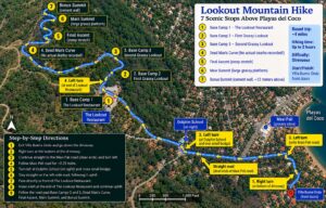
Illustrated route map with the seven stops and turn-by-turn directions. Verify the route against Google Earth before using this illustration for navigation.
VILLA BUENA ONDA — BASE CAMP FOR EPIC ADVENTURES